Tropical Storm Lowell Is Forecast to Become a Major Hurricane. Here’s When Hawaii Will Feel It.
Hawaii travel news can change quickly. Always confirm current details with official sources before making travel plans.
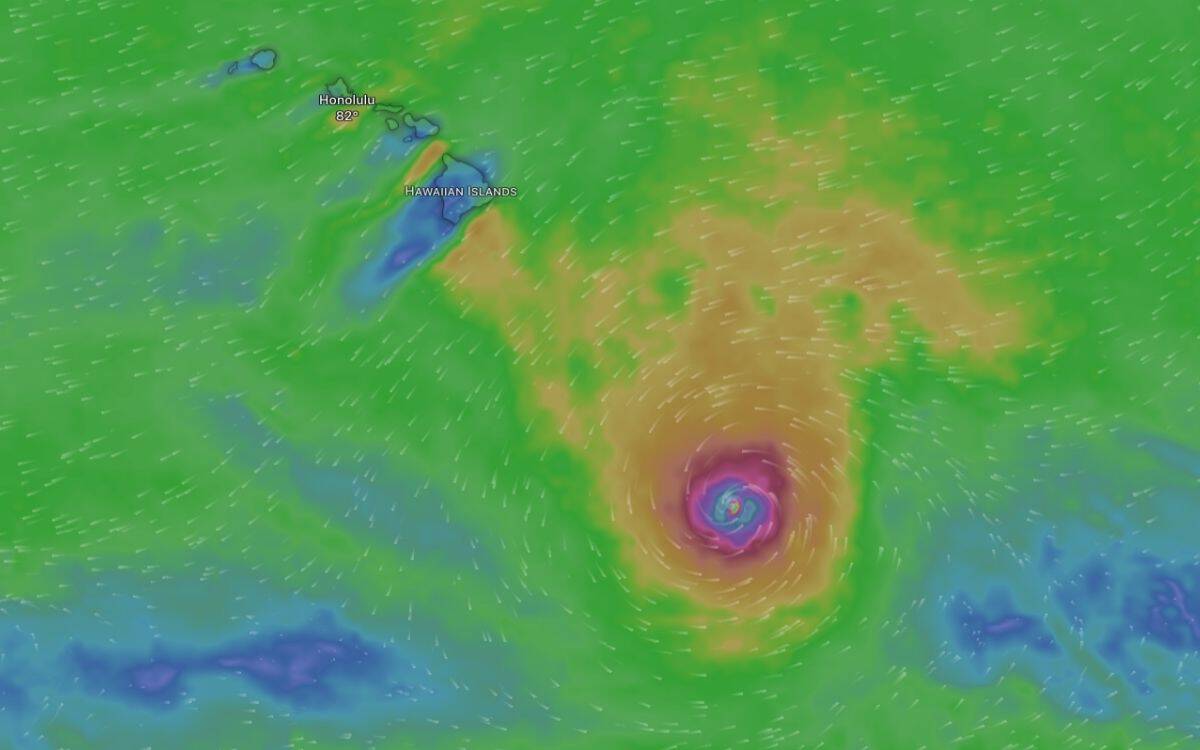
Tropical Storm Lowell is forecast to intensify into a Category 3 major hurricane and pass roughly 300 miles south of the Big Island late Wednesday into Thursday.
The storm won’t make landfall, but Hawaii will feel it.
Strong gusty winds, high surf, and enhanced showers are expected across the islands, with the highest impacts Wednesday afternoon through Friday.
Visitors and locals with plans for Labor Day weekend face a trickier forecast. Hurricane Karina is approaching from the east, and the interaction between the two storms creates significant uncertainty for the weekend.
The question isn’t whether you’ll see some weather. It’s whether your trip will mostly go as planned, or whether you’ll need to shift gears.
Here’s the timeline, the impacts, and what you should watch next.
TL;DR: Tropical Storm Lowell Forecast for Hawaii
Tropical Storm Lowell is forecast to become a Category 3 hurricane and pass about 300 miles south of the Big Island Wednesday night into Thursday. No Tropical Storm or Hurricane Watch or Warning is expected for Hawaii, but impacts will be felt statewide.
- What’s happening: Lowell is intensifying rapidly and will pass south of Hawaii as a major hurricane Wednesday into Thursday.
- Who’s affected: All islands, with the Big Island seeing the closest pass and strongest impacts.
- When: Wednesday afternoon through Friday, with winds possibly gusting over 50 mph.
- Should this change your trip? Not if you’re flexible. Expect windy conditions, high surf, possible flight delays, and park closures. Outdoor activities may be limited. The bigger uncertainty is Labor Day weekend, when Hurricane Karina may also be nearby.
- What to watch next: National Weather Service and airline updates. The forecast remains uncertain for the weekend.
🎧 Listen: 90-Second Audio Brief
Short on time? Listen to this quick overview while you pack or commute.
Tropical Storm Lowell is about 500 miles southeast of the Big Island and strengthening
As of Tuesday morning, September 1, Tropical Storm Lowell was located about 500 miles southeast of Hilo. Maximum sustained winds were near 65 mph, and the storm was moving west at 14 mph.
The National Hurricane Center forecasts Lowell will strengthen into a hurricane within 12 hours and reach Category 3 major hurricane strength by Wednesday. The latest forecast track has Lowell passing just over 300 miles south of the Big Island Wednesday night into Thursday.
The storm will stay far enough offshore that no Tropical Storm or Hurricane Watch or Warning is expected for the Hawaiian Islands. But the pressure gradient between Lowell to the south and a strong high-pressure system far north of the state will tighten, producing very strong and gusty trade winds across Hawaii.
This isn’t a direct hit. But it’s close enough that you’ll notice.
When Hawaii will feel Tropical Storm Lowell
Tuesday (Today):
Breezy trade winds and scattered showers, especially over windward and mountain areas. Moisture from Lowell will begin to spread across the islands, increasing shower activity tonight. Dewpoints will climb into the low 70s, making the air muggier than usual.
Wednesday:
Trade winds will strengthen Wednesday afternoon and may reach Wind Advisory levels in typically windy spots. Gusts over 50 mph are possible. Outer rainbands from Lowell could bring heavier passing showers, though the bulk of the storm’s moisture will pass south of the state. A moderate south swell will build and peak Wednesday, bringing surf just below High Surf Advisory thresholds on south-facing shores, especially the Big Island.
Thursday and Friday:
Winds will remain strong and gusty, with gusts over 50 mph possible in exposed areas. Showers will favor windward and mountain areas. South shore surf will stay elevated near advisory levels through Friday. Rough, choppy conditions will continue along east-facing shores due to trade wind swell.
This Weekend (Labor Day):
High uncertainty. Lowell is forecast to turn north after passing west of the state, but the timing of that turn is unclear. Hurricane Karina will also be within 600 miles of the Big Island by Saturday. The interaction between the two systems could bring additional wind, surf, and rain, or the storms could stay far enough away that conditions improve. Check forecasts daily.
What travelers should expect: wind, surf, and rain
Wind:
Expect strong and gusty trade winds Wednesday afternoon through Friday, with gusts possibly exceeding 50 mph in typical wind-prone areas like the saddle between Mauna Kea and Mauna Loa on the Big Island, parts of Maui, and windward coastal zones. A Wind Advisory is likely, though fuel conditions are not at critical fire danger levels thanks to recent rainfall.
The winds won’t be hurricane-force in Hawaii, but they’ll be strong enough to make outdoor activities uncomfortable and possibly unsafe. Beach umbrellas, pop-up tents, and loose items should be secured.
Surf:
A moderate, long-period south swell will peak Wednesday, bringing surf to just below High Surf Advisory levels on south-facing shores. The Big Island’s south shore will see the highest surf first. Other islands will see impacts Thursday into Friday.
Beyond Friday, the surf forecast depends entirely on Lowell’s track. If the storm turns sharply north, it could generate significant south to southwest swell through the weekend. East shore surf will also remain elevated due to trade wind swell, with a medium-period east swell from Hurricane Karina building through the week.
Rain:
Passing trade wind showers will favor windward and mountain areas, especially overnight and in the early morning. The bulk of Lowell’s moisture will pass south of the state, so widespread heavy rain is not expected unless the storm tracks farther north than currently forecast. Flash flooding potential is limited at this time, but that could change if the forecast shifts.
If you’re looking for things to do in Hawaii when it rains, have a backup plan ready. Museums, indoor attractions, shopping, and covered dining areas are your friends this week.
Flight delays and airport impacts
Strong winds can cause flight delays, especially during takeoff and landing. Honolulu’s Daniel K. Inouye International Airport and the neighbor island airports are built to handle windy conditions, but crosswinds and gusts can still slow operations.
If you’re flying Wednesday through Friday, build in extra time. Check your airline’s app for real-time updates. Rebooking waivers have not been issued as of Tuesday morning, but that could change if conditions worsen.
Interisland flights on smaller aircraft may be more affected than wide-body jets on transpacific routes. If you have a tight connection or a same-day interisland hop, consider adding buffer time or flexibility to your itinerary.
Park and beach closures likely
State parks, beaches, and trails on windward and exposed coasts may close if conditions become unsafe. The National Park Service has not yet announced closures at Hawaii Volcanoes National Park or Haleakalā National Park, but check park websites and social media before heading out.
South-facing beaches will see higher surf Wednesday into Friday. Lifeguards may post warning flags or close beaches if conditions become dangerous. Snorkeling, stand-up paddleboarding, and other ocean activities should be approached with caution.
If you’re visiting the Big Island’s best beaches, call ahead or check county beach websites for closure updates.
The Labor Day weekend wild card: Hurricane Karina
Lowell isn’t the only storm in play. Hurricane Karina, currently a Category 4 hurricane about 1,500 miles east of the Big Island, is forecast to move into the Central Pacific basin by Thursday night.
The latest forecast from the National Hurricane Center has Karina about 600 miles east of the Big Island by Saturday. Gradual weakening is expected, but Karina could still be a major hurricane or strong tropical storm when it reaches Hawaiian waters.
The forecast spread increases drastically for the Labor Day weekend. Several models show Lowell taking a sharp northward turn over the weekend. If that happens, and if Karina also moves closer, Hawaii could see additional wind, surf, and rain impacts.
Right now, confidence is high that Lowell will pass south of the state Wednesday through Friday. Confidence is low for what happens this weekend. The National Weather Service and Central Pacific Hurricane Center will issue updated forecasts daily. Check hurricanes.gov for the official track and intensity forecast.
What visitors should do right now
If you’re in Hawaii now or arriving this week:
- Monitor the National Weather Service Honolulu for daily updates.
- Check your airline’s app for flight status and delays.
- Secure loose items outside your rental or accommodation. Bring in patio furniture, umbrellas, and beach gear.
- Fill up your rental car’s gas tank. Gas stations can get busy before and after storms.
- Have a backup plan for outdoor activities. Indoor attractions and covered dining will be your best bet Wednesday through Friday.
- Download offline maps and save important phone numbers in case cell service is spotty.
If you’re arriving Labor Day weekend:
- Watch the forecast closely. The interaction between Lowell and Karina could change conditions quickly.
- Consider travel insurance if you haven’t purchased it already. Policies typically need to be bought within 14 days of your first trip deposit to cover pre-existing conditions like named storms.
- Stay flexible. If conditions worsen, airlines may issue rebooking waivers. Keep an eye on your carrier’s travel advisory page.
If you’re planning a Big Island trip soon:
The best time to visit the Big Island is typically outside of hurricane season, but September is still a beautiful month when storms stay away. This week is an exception. If you can shift your dates, mid-September onward usually sees calmer conditions.
The bottom line
Lowell will pass south of Hawaii as a major hurricane, close enough to bring strong winds, high surf, and enhanced showers Wednesday through Friday. The storm won’t make landfall, and no Hurricane or Tropical Storm Watch or Warning is expected for the islands. But you’ll feel it.
The bigger question mark is Labor Day weekend. Hurricane Karina is also approaching, and the forecast beyond Friday is highly uncertain. If you’re flexible, patient, and prepared for a few rough weather days, your trip can still go well. If you were counting on perfect beach weather and calm seas, this isn’t the week.
Hawaii has weathered storms before. The islands are prepared, the infrastructure is solid, and locals know the drill. As a visitor, your job is to stay informed, stay flexible, and respect ocean and weather warnings. The aloha spirit doesn’t stop for wind and rain, but it does ask you to be smart about it.
Stay safe, check forecasts daily, and enjoy the islands once the weather clears.
FAQ
Is Tropical Storm Lowell going to hit Hawaii?
No. Lowell is forecast to pass about 300 miles south of the Big Island Wednesday night into Thursday as a Category 3 hurricane. The storm will stay far enough offshore that no Hurricane or Tropical Storm Watch or Warning is expected for Hawaii. However, the islands will experience strong gusty winds, high surf, and enhanced showers as a result of the storm’s proximity.
When will Hawaii feel the effects of Tropical Storm Lowell?
Hawaii will begin to feel the effects Tuesday night, with increasing shower activity and rising humidity. Conditions will worsen Wednesday afternoon as trade winds strengthen and may gust over 50 mph. The strongest impacts are expected Wednesday night through Friday, with high surf on south-facing shores and rough, windy conditions statewide.
Should I cancel my Hawaii trip because of Tropical Storm Lowell?
If you’re arriving Wednesday through Friday and are flexible with outdoor activities, you don’t need to cancel. Expect windy weather, high surf, possible flight delays, and limited beach time. Have backup plans for indoor activities and covered dining. If you’re arriving Labor Day weekend, the forecast is more uncertain due to Hurricane Karina’s approach. Monitor forecasts closely and consider travel insurance if you haven’t purchased it already.
Will flights to Hawaii be canceled because of Tropical Storm Lowell?
Flights are not expected to be canceled, but delays are possible Wednesday through Friday due to strong crosswinds. Check your airline’s app for real-time updates. Interisland flights on smaller aircraft may be more affected than transpacific flights on larger jets. Build in extra time for connections and airport procedures.
What should I do if I’m already in Hawaii during Tropical Storm Lowell?
Stay informed by monitoring the National Weather Service Honolulu and your airline’s travel advisories. Secure loose items outside your rental or accommodation. Fill up your car’s gas tank. Have backup plans for outdoor activities. Avoid the ocean if High Surf Advisories are in effect. Download offline maps and save important phone numbers in case cell service is affected.
What is the forecast for Labor Day weekend in Hawaii?
The forecast for Labor Day weekend is highly uncertain. Tropical Storm Lowell is expected to turn north after passing west of Hawaii, and Hurricane Karina will be within 600 miles of the Big Island by Saturday. The interaction between the two storms could bring additional wind, surf, and rain, or conditions could improve if both storms stay far enough away. Check the National Weather Service and Central Pacific Hurricane Center for daily updates.
Sources
KHON2 News – “Lowell forecast to pass south of Hawaii as major hurricane“
Big Island Now – Hawaii County Weather Forecast for September 01, 2026
Hawaii News Now – “Lowell set to rapidly intensify, Karina continues westward track toward Hawaii“
RECOMMENDED POSTS
Iao Valley Closure Extended (Again) Now Through August 7. Here’s What Maui Travelers Should Do.
[dssb_sharing_buttons icon_placement="icon" columns="2" _builder_version="4.24.3" _module_preset="default" box_shadow_style_icon="preset1"...
Traveling to Hawaii This Week? What Hurricane Fausto Actually Means for Your Trip
[dssb_sharing_buttons columns="5" icon_width="fixed" alignment="left" icon_color="#000000" use_custom_icon_size="on" icon_font_size="16px"...
Hawaiian Airlines Is Retiring Its Interisland Planes
[dssb_sharing_buttons columns="5" icon_width="fixed" alignment="left" icon_color="#000000" use_custom_icon_size="on" icon_font_size="16px"...
Bryan Murphy is the creator of Hawaii's Best Travel and host of the Hawaii's Best podcast, a top-30 U.S. travel podcast with 700,000+ downloads and a 4.9-star rating from 280+ reviews on Apple Podcasts. A Certified Hawaii Destination Expert and member of the Hawaii Visitors & Convention Bureau, he helps visitors plan more meaningful trips to Hawaii with practical, respectful guidance. His work has been featured in Travel + Leisure, National Geographic, Yahoo!, Simple Flying, USA Today, Parents, and Fox.